


Anchor Alarm - SailGrib AA
Deskripsi Anchor Alarm - SailGrib AA
Anchor Alarm oleh SailGrib, adalah aplikasi alarm jangkar berfitur lengkap modern.
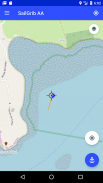
- Mulai aplikasi sebelum jangkar Anda, aplikasi akan merekam dan menggambar trek Anda di peta.
- Tinggalkan telepon Anda di atas tabel grafik.
- Moore tanpa mengkhawatirkan aplikasi.
- Kembali ke aplikasi. Di trek, cari titik yang sesuai dengan posisi perahu pada saat berlabuh. Anda seharusnya dapat mendeteksinya dengan relatif mudah di peta berkat gerakan mundur setelah penahan.
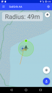
- Pusatkan peta pada titik jangkar menggunakan tanda target di tengah layar.
- Tekan tombol biru "Jangkar" untuk memperbaiki posisi jangkar.
- Sesuaikan radius area pembasahan dengan menggerakkan titik hijau ke tepi zona.
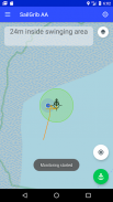
- Perbaiki area pembasahan dengan menekan tombol "Anchor" lagi, berubah menjadi hijau. Alarm diaktifkan.
BARU: Gunakan grafik berperahu Navionik Anda di dalam aplikasi!
Dengan opsi Premium:
- Tentukan zona pembasahan heksagonal dan dapat diedit di layar.
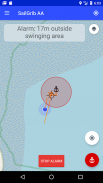
- Mengirim email saat alarm dibunyikan.
- Lihat peta SailGrib WR.
- Impor jejak GPX dari SailGrib WR jika Anda lupa untuk memulai aplikasi sebelum membasahi.
Aplikasi berjalan di latar belakang dan menggunakan teknik Android terbaru untuk mengurangi konsumsi daya sekaligus memaksimalkan akurasi posisi.
Perhatikan bahwa keakuratan posisi Anda bergantung pada ponsel dan lokasi Anda. Mulai Maret 2021, kami menganggap bahwa sebagian besar ponsel memiliki akurasi antara 2 dan 10 meter saat berada di laut.
Anchor Alarm - SailGrib AA - Versi 3.2
(06-10-2023)Anchor Alarm - SailGrib AA - Informasi APK
Versi APK: 3.2Paket: com.sailgrib.anchoralarmVersi Terakhir dari Anchor Alarm - SailGrib AA
Versi lain


Aplikasi pada kategori yang sama

Anda juga mungkin suka...
Aplikasi pada kategori yang sama


